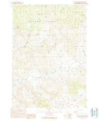
1990 Map of Bologna Basin
USGS Topo · Published 1990About this map
The North Fork John Day River carves through this portion of Grant County, serving as the primary drainage for a landscape defined by deep canyons and seasonal water sources. The northern reaches are dominated by the Umatilla National Forest, where features like Bologna Basin and Bologna Canyon suggest the early ranching and grazing history of the region. Significant landmarks such as Thorn Spring Butte and Ant Hill provide vertical relief above the intricate network of tributary drainages including Rains Canyon and Portuguese Canyon.
Find a feature on this map
25 named features on this map. Tap any name to fly to it.
Don’t see what you’re looking for? This feature index may not catch every label — zoom into the map to look around manually.
Map Details
Editions of this 1990 Bologna Basin Map
This is the sole edition of this map. No revisions or reprints were ever made.
Other maps of this area

1951 · Courtrock
USGS Topo · 1:62,500

1951 · Monument
USGS Topo · 1:62,500

1953 · Kimberly
USGS Topo · 1:62,500

1953 · Picture
USGS Topo · 1:62,500

1955 · Canyon City
USGS Topo · 1:250,000

1959 · Canyon City
USGS Topo · 1:250,000

1980 · Monument
USGS Topo · 1:100,000
1990 · Monument
USGS Topo · 1:24,000
1990 · Miller Flat
USGS Topo · 1:24,000
1990 · Turner Mountain
USGS Topo · 1:24,000