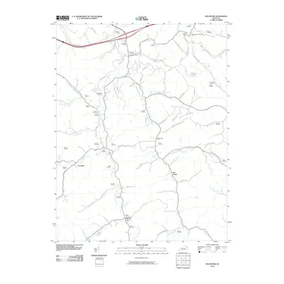
2010 Map of Boltsfork
USGS Topo · Published 2010About this map
Boltsfork and the surrounding Boyd County hills are defined by a network of creeks and small family cemeteries in this 2010 topographic survey. The East Fork Little Sandy River serves as the primary drainage corridor, with numerous tributaries like Ellington Bear Creek and Fourmile Creek carving through the terrain. Evidence of rural community centers remains through the locations of the Alley Post Office and the Bolton Post Office, while the landscape is dotted with dozens of genealogical landmarks such as the Musick Cemetery, Fields Cemetery, and Queen Cemetery.
Find a feature on this map
87 named features on this map. Tap any name to fly to it.
Don’t see what you’re looking for? This feature index may not catch every label — zoom into the map to look around manually.
Map Details
Editions of this 2010 Boltsfork Map
This is the sole edition of this map. No revisions or reprints were ever made.
Other maps of this area

1901 · Ceredo
USGS Topo · 1:62,500

1903 · Kenova
USGS Topo · 1:125,000

1904 · Kenova
USGS Topo · 1:125,000

1911 · Louisa
USGS Topo · 1:48,000

1913 · Ceredo
USGS Topo · 1:62,500

1913 · Louisa
USGS Topo · 1:62,500

1939 · Louisa
USGS Topo · 1:62,500
1953 · Prichard
USGS Topo · 1:24,000

1953 · Rush
USGS Topo · 1:24,000

1953 · Boltsfork
USGS Topo · 1:24,000