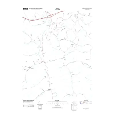
2013 Map of Boltsfork
USGS Topo · Published 2013About this map
The E Fork Little Sandy River carves a winding path through this region of Boyd County, anchoring a landscape defined by narrow valleys and numerous small settlements. The community of Boltsfork sits at a southern crossroads near the junction of Bolts Fork and the main river, serving as a focal point for local transport and commerce. To the north, the village of Mavity occupies a similar riverside position, while Trace and Cloverdale represent established hubs along the western roads.
Find a feature on this map
136 named features on this map. Tap any name to fly to it.
Don’t see what you’re looking for? This feature index may not catch every label — zoom into the map to look around manually.
Map Details
Editions of this 2013 Boltsfork Map
This is the sole edition of this map. No revisions or reprints were ever made.
Other maps of this area

1901 · Ceredo
USGS Topo · 1:62,500

1903 · Kenova
USGS Topo · 1:125,000

1904 · Kenova
USGS Topo · 1:125,000

1911 · Louisa
USGS Topo · 1:48,000

1913 · Ceredo
USGS Topo · 1:62,500

1913 · Louisa
USGS Topo · 1:62,500

1939 · Louisa
USGS Topo · 1:62,500
1953 · Prichard
USGS Topo · 1:24,000

1953 · Rush
USGS Topo · 1:24,000

1953 · Boltsfork
USGS Topo · 1:24,000