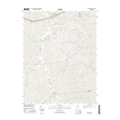
2016 Map of Boltsfork
USGS Topo · Published 2016About this map
The E Fork Little Sandy River carves a central path through this section of Boyd and Lawrence Counties, defining a landscape of narrow hollows and high ridges. Small communities like Cannonsburg, Mavity, and Boltsfork are connected by a network of rural roads that follow the winding drainages of Fourmile Cr and Trace Cr. The density of family-named burial grounds, including the Bates and Crum Cem and the McGlothen Cem, reflects a deep-rooted settlement pattern where generations of families remained on their ancestral land. This 2016 survey documents the enduring rural character of the area near Laurel Ridge, where landmarks like Davis Gap and Laurel Gap serve as historical passage points between the steep drainages of Bear Cr and Durbin Cr.
Find a feature on this map
121 named features on this map. Tap any name to fly to it.
Don’t see what you’re looking for? This feature index may not catch every label — zoom into the map to look around manually.
Map Details
Editions of this 2016 Boltsfork Map
This is the sole edition of this map. No revisions or reprints were ever made.
Other maps of this area

1901 · Ceredo
USGS Topo · 1:62,500

1903 · Kenova
USGS Topo · 1:125,000

1904 · Kenova
USGS Topo · 1:125,000

1911 · Louisa
USGS Topo · 1:48,000

1913 · Ceredo
USGS Topo · 1:62,500

1913 · Louisa
USGS Topo · 1:62,500

1939 · Louisa
USGS Topo · 1:62,500
1953 · Prichard
USGS Topo · 1:24,000

1953 · Rush
USGS Topo · 1:24,000

1953 · Boltsfork
USGS Topo · 1:24,000