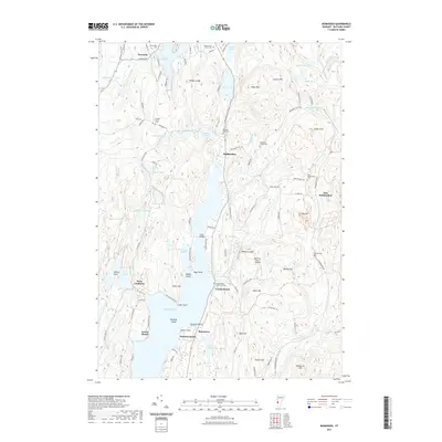
2021 Map of Bomoseen
USGS Topo · Published 2021About this map
Lake Bomoseen dominates this landscape in Rutland County, where the shoreline is punctuated by early 21st-century residential developments and recreational points like Crystal Beach and Avalon Beach. The terrain is characterized by a series of north-south ridges and valleys, featuring landmarks such as Cedar Mtn and Zion Hill. This topography shaped the local settlement patterns, concentrating communities like Hortonia and Hubbardton along the narrow corridors between the water and the rising slopes. Genealogists will find a high density of burial sites reflecting the area's long history, including the Bradley Family Cem, Hortonville Cem, and the uniquely named Crystal Beach Town Farm Cem. Water remains the defining element of the region, from the smaller Beebe Pond and Echo Lake in the north to the Hubbardton River which winds through the western valley near West Castleton.
Find a feature on this map
112 named features on this map. Tap any name to fly to it.
Don’t see what you’re looking for? This feature index may not catch every label — zoom into the map to look around manually.
Map Details
Editions of this 2021 Bomoseen Map
This is the sole edition of this map. No revisions or reprints were ever made.
Other maps of this area

1893 · Whitehall
USGS Topo · 1:62,500

1894 · Ticonderoga
USGS Topo · 1:62,500

1895 · Whitehall
USGS Topo · 1:62,500

1895 · Castleton
USGS Topo · 1:62,500

1896 · Ticonderoga
USGS Topo · 1:62,500

1897 · Castleton
USGS Topo · 1:62,500

1898 · Whitehall
USGS Topo · 1:62,500

1902 · Whitehall
USGS Topo · 1:62,500

1902 · Ticonderoga
USGS Topo · 1:62,500

1902 · Brandon
USGS Topo · 1:62,500