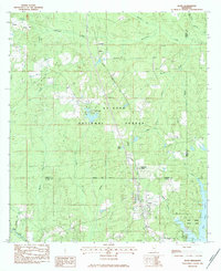
1983 Map of Bond
USGS Topo · Published 1984About this map
Bond and Fruitland Park anchor the southeastern corridor of this landscape, situated along the Illinois Central Gulf railroad line. The map illustrates a region defined by the deep woods of the De Soto National Forest and the industrial activity of the Maxie Gas Field. To the north, the small settlement of Maxie and the community at Carnes sit near several family-named landmarks and historical sites, including Batson Cem and Cotton Ridge Ch. The terrain is crisscrossed by numerous waterways such as Beaverdam Creek and Caney Creek, which flow toward the Flint Creek Water Park and its substantial reservoir in the southeast. This survey documents the area during a period of established forestry and energy extraction, capturing the location of specialized sites like Camp Iti Kana and the Pumping Station near the western boundary.
Find a feature on this map
36 named features on this map. Tap any name to fly to it.
Don’t see what you’re looking for? This feature index may not catch every label — zoom into the map to look around manually.
Map Details
Editions of this 1983 Bond Map
This is the sole edition of this map. No revisions or reprints were ever made.
Other maps of this area

1947 · Wiggins
USGS Topo · 1:62,500

1947 · New Augusta
USGS Topo · 1:62,500

1949 · Wiggins
USGS Topo · 1:62,500

1949 · New Augusta
USGS Topo · 1:62,500

1953 · Hattiesburg
USGS Topo · 1:250,000

1953 · Mobile
USGS Topo · 1:250,000

1957 · Mobile
USGS Topo · 1:250,000

1958 · Hattiesburg
USGS Topo · 1:250,000

1958 · Carnes
USGS Topo · 1:62,500

1960 · Mobile
USGS Topo · 1:250,000