
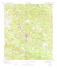
1947 Map of Wiggins
USGS Topo · Published 1965About this map
The Illinois Central railroad corridor serves as the central spine of this mid-century survey, connecting timber and agricultural outposts across the southern Mississippi piney woods. Within the De Soto National Forest, the landscape is defined by a dense network of creek drainages like Black Creek and Bluff Creek, while the Maxie Fire Tower stands as a sentinel over the wooded terrain. The primary settlement of Wiggins functions as a regional hub, anchored by its prominent Water Tower.
Find a feature on this map
86 named features on this map. Tap any name to fly to it.
Don’t see what you’re looking for? This feature index may not catch every label — zoom into the map to look around manually.
Map Details
Editions of this 1947 Wiggins Map
2 editions found
Other maps of this area

1947 · Beaumont
USGS Topo · 1:62,500

1947 · New Augusta
USGS Topo · 1:62,500

1947 · Benndale
USGS Topo · 1:62,500

1949 · Wiggins
USGS Topo · 1:62,500

1949 · Beaumont
USGS Topo · 1:62,500

1949 · New Augusta
USGS Topo · 1:62,500

1949 · Benndale
USGS Topo · 1:62,500

1953 · Hattiesburg
USGS Topo · 1:250,000

1953 · Mobile
USGS Topo · 1:250,000
1954 · Vestry
USGS Topo · 1:62,500