
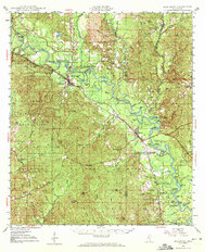
1947 Map of Beaumont
USGS Topo · Published 1963About this map
The Leaf River snakes through the heart of this post-war landscape, carving a complex path of oxbow lakes and sandbars such as Longfield Sandbar. This region of the De Soto National Forest is defined by its timber and rail connections, with the Gulf Mobile & Ohio and Southern Railway intersecting at Beaumont. The eastern portion of Camp Shelby Military Reservation occupies the western edge of the sheet, while small settlements like McLain and Kittrell serve as local hubs for rural communities. Genealogists will find significant value in the scattered country churches and burial grounds, including Moody Chapel, Sylvester Cem, and Union Ch. The terrain transitions from the low river bottomlands to named heights like Hillman Hills and Wolf Hill, illustrating the varied topography of Perry and Greene Counties.
Find a feature on this map
104 named features on this map. Tap any name to fly to it.
Don’t see what you’re looking for? This feature index may not catch every label — zoom into the map to look around manually.
Map Details
Editions of this 1947 Beaumont Map
2 editions found
Other maps of this area

1941 · Lucedale
USGS Topo · 1:62,500

1943 · Lucedale
USGS Topo · 1:62,500

1947 · Wiggins
USGS Topo · 1:62,500

1947 · New Augusta
USGS Topo · 1:62,500

1947 · Benndale
USGS Topo · 1:62,500

1949 · Wiggins
USGS Topo · 1:62,500

1949 · Beaumont
USGS Topo · 1:62,500

1949 · New Augusta
USGS Topo · 1:62,500

1949 · Benndale
USGS Topo · 1:62,500

1953 · Hattiesburg
USGS Topo · 1:250,000