
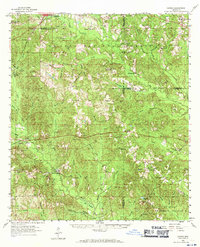
1958 Map of Carnes
USGS Topo · Published 1959About this map
Lumberton stands at the northwestern corner of this territory, where the landscape transitions into the expansive De Soto National Forest. The map reveals a rural community structured around small schools and country churches, many of which are tied to family names and local landmarks like Pistol Ridge. The presence of several abandoned institutions, such as Bird Line Sch and Thomas Sch, suggests a shift in the local population or educational consolidation during the mid-20th century.
Find a feature on this map
84 named features on this map. Tap any name to fly to it.
Don’t see what you’re looking for? This feature index may not catch every label — zoom into the map to look around manually.
Map Details
Editions of this 1958 Carnes Map
2 editions found
Other maps of this area

1947 · Wiggins
USGS Topo · 1:62,500

1947 · New Augusta
USGS Topo · 1:62,500

1949 · Wiggins
USGS Topo · 1:62,500

1949 · New Augusta
USGS Topo · 1:62,500

1953 · Hattiesburg
USGS Topo · 1:250,000

1953 · Mobile
USGS Topo · 1:250,000

1954 · McHenry
USGS Topo · 1:62,500

1955 · Savannah
USGS Topo · 1:62,500

1957 · Mobile
USGS Topo · 1:250,000

1958 · Hattiesburg
USGS Topo · 1:250,000