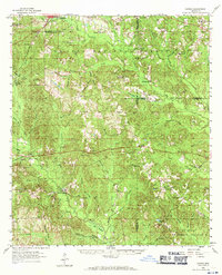
1958 Map of Carnes
USGS Topo · Published 1971About this map
De Soto National Forest dominates this mid-century landscape in southern Mississippi, where the piney woods are dissected by an intricate drainage system including Wolf Creek, Juniper Creek, and Turkey Creek. The map documents a rural transition as former educational centers like Bird Line Sch (Abandoned) and Thomas Sch (Abandoned) gave way to newer facilities such as Progress Sch. Evidence of the region's timber and rail history remains visible through an Old Railroad Grade and the presence of the Bilbo Lookout Tower and Lee Lookout Tower, which monitored the timberlands from high points like Pistol Ridge. Family heritage is deeply rooted here, marked by numerous rural sanctuaries and burial grounds such as Hickory Grove Ch, Sandhill Ch, and Daughdrill Cem. Small settlements like Hillsdale and Carnes serve as focal points in an area defined by its brakes and prongs, such as Bee Tree Brake and Near Prong.
Find a feature on this map
85 named features on this map. Tap any name to fly to it.
Don’t see what you’re looking for? This feature index may not catch every label — zoom into the map to look around manually.
Map Details
Editions of this 1958 Carnes Map
2 editions found

Other maps of this area

1947 · Wiggins
USGS Topo · 1:62,500

1947 · New Augusta
USGS Topo · 1:62,500

1949 · Wiggins
USGS Topo · 1:62,500

1949 · New Augusta
USGS Topo · 1:62,500

1953 · Hattiesburg
USGS Topo · 1:250,000

1953 · Mobile
USGS Topo · 1:250,000

1954 · McHenry
USGS Topo · 1:62,500

1955 · Savannah
USGS Topo · 1:62,500

1957 · Mobile
USGS Topo · 1:250,000

1958 · Hattiesburg
USGS Topo · 1:250,000