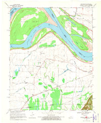
1969 Map of Bondurant
USGS Topo · Published 1972About this map
The Mississippi River defines this landscape where Kentucky, Missouri, and Tennessee meet in a complex network of wetlands and river bends. The settlement at Sassafras Ridge serves as a focal point for local history, surrounded by rural institutions like Corner Stone Ch, Western Sch, and Johnson Chapel. The terrain is characterized by numerous water bodies, including Fish Pond and the extensive Reelfoot National Wildlife Refuge to the south. This area is a patchwork of sloughs such as Cypress Slough and Running Slough, illustrating the natural drainage patterns of the floodplains before modern engineering fully altered the river's course. Traces of the Central Illinois Railroad line provide evidence of the era's transport economy, connecting small communities like Bondurant and Tyler to the wider region.
Find a feature on this map
46 named features on this map. Tap any name to fly to it.
Don’t see what you’re looking for? This feature index may not catch every label — zoom into the map to look around manually.
Map Details
Editions of this 1969 Bondurant Map
2 editions found
Other maps of this area

1925 · Reelfoot Lake
USGS Topo · 1:62,500

1939 · Reelfoot Lake
USGS Topo · 1:62,500

1939 · Hickman
USGS Topo · 1:62,500

1939 · Bayouville
USGS Topo · 1:62,500

1951 · Bondurant
USGS Topo · 1:24,000

1951 · Hickman
USGS Topo · 1:24,000

1951 · Wolf Island
USGS Topo · 1:24,000

1951 · Hubbard Lake
USGS Topo · 1:24,000

1954 · Hickman
USGS Topo · 1:62,500
1955 · Hickman
USGS Topo · 1:62,500