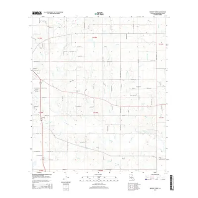
2015 Map of Boneset Creek
USGS Topo · Published 2015About this map
Bundick Creek and its many tributaries, including Boneset Creek, define the drainage of this central Louisiana landscape north of the Calcasieu River basin. Small rural settlements like Longacre and Ikes serve as anchors for a network of local roads such as La-1146 and Legion Rd. The map is particularly useful for genealogical research, documenting several dispersed family and community burial grounds including Whitaker Cem, Pleasant Hill Cem, and Hopwell Cem near Hopewell Church Rd. The terrain is etched by numerous branches and hollows, such as Turkey Hollow Cr, Tiger Br, and Beemouth Br, illustrating a landscape dominated by timber and small-scale agriculture. The survey also captures the grid of the Public Land Survey System, showing the township and range lines that have governed land ownership since the region's early development.
Find a feature on this map
105 named features on this map. Tap any name to fly to it.
Don’t see what you’re looking for? This feature index may not catch every label — zoom into the map to look around manually.
Map Details
Editions of this 2015 Boneset Creek Map
This is the sole edition of this map. No revisions or reprints were ever made.
Other maps of this area

1947 · DeRidder
USGS Topo · 1:31,680

1947 · Rosepine
USGS Topo · 1:31,680

1947 · Ikes
USGS Topo · 1:31,680

1947 · Chasmore
USGS Topo · 1:31,680

1947 · Bundick
USGS Topo · 1:31,680

1947 · Beckwith School
USGS Topo · 1:31,680

1947 · Sugartown
USGS Topo · 1:31,680

1947 · Bannister
USGS Topo · 1:31,680

1947 · Sugrue
USGS Topo · 1:31,680
1950 · Dry Creek
USGS Topo · 1:24,000