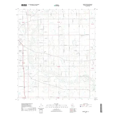
2018 Map of Boneset Creek
USGS Topo · Published 2018About this map
The settlement of Ikes and the winding course of Bundick Cr dominate this portion of Beauregard Parish, where a network of family-named roads reveals the deep roots of local heritage. The landscape is defined by its extensive hydrography, featuring numerous branches and creeks such as Boneset Cr, Turkey Hollow Cr, and Beemouth Br. These waterways cut through the terrain, influencing the placement of early infrastructure and homesteads. Local history is anchored by several burial grounds, including Pleasant Hill Cem, Whitaker Cem, and Hopwell Cem, which serve as vital landmarks for genealogical research. The southern portion of the map is marked by Bundick Lake, a significant water body formed along the creek. The presence of roads like Three Pine Church Rd, American Legion Rd, and Lewis Cemetery Rd points to the community-centered layout of the area, where rural churches and cemeteries provided the primary social and geographical nodes for the surrounding residents.
Find a feature on this map
94 named features on this map. Tap any name to fly to it.
Don’t see what you’re looking for? This feature index may not catch every label — zoom into the map to look around manually.
Map Details
Editions of this 2018 Boneset Creek Map
This is the sole edition of this map. No revisions or reprints were ever made.
Other maps of this area

1947 · DeRidder
USGS Topo · 1:31,680

1947 · Rosepine
USGS Topo · 1:31,680

1947 · Ikes
USGS Topo · 1:31,680

1947 · Chasmore
USGS Topo · 1:31,680

1947 · Bundick
USGS Topo · 1:31,680

1947 · Beckwith School
USGS Topo · 1:31,680

1947 · Sugartown
USGS Topo · 1:31,680

1947 · Bannister
USGS Topo · 1:31,680

1947 · Sugrue
USGS Topo · 1:31,680
1950 · Dry Creek
USGS Topo · 1:24,000