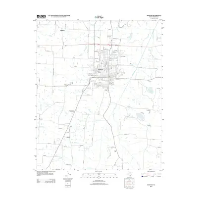
2013 Map of Bonham
USGS Topo · Published 2013About this map
Bonham serves as the focal point of this North Texas study, anchored by its historic transportation infrastructure. The Texas and Pacific Railroad Depot stands as a testament to the town's growth, while the surrounding landscape is marked by a high density of ancestral sites, including Inglish Cem, Willow Wild Cem, and Gates Hill Cem. Beyond the city grid, the terrain transitions into the watershed of Bois d'Arc Cr, where smaller communities such as Midway, English, and Edhube are situated among a network of rural roads and county routes. The presence of Jones Field Airport to the north and the nearby City Lake provides a look at the modern civic development and water management strategies of Fannin County. Topographical features like Arledge Ridge break the primarily level landscape, which is drained by numerous seasonal and permanent waterways including Sloans Cr and Cooper Cr.
Find a feature on this map
142 named features on this map. Tap any name to fly to it.
Don’t see what you’re looking for? This feature index may not catch every label — zoom into the map to look around manually.
Map Details
Editions of this 2013 Bonham Map
This is the sole edition of this map. No revisions or reprints were ever made.
Other maps of this area

1954 · Sherman
USGS Topo · 1:250,000

1958 · Bonham
USGS Topo · 1:62,500

1958 · Whitesright
USGS Topo · 1:62,500

1958 · Sherman
USGS Topo · 1:250,000

1964 · Trenton
USGS Topo · 1:24,000
1964 · Gober
USGS Topo · 1:24,000
1964 · Leonard
USGS Topo · 1:24,000
1984 · Lamasco
USGS Topo · 1:24,000
1984 · Dodd City
USGS Topo · 1:24,000
1984 · Lake Bonham
USGS Topo · 1:24,000