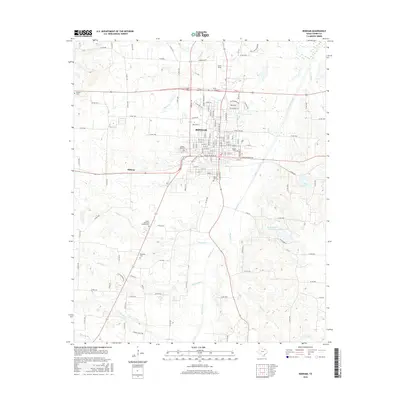
2016 Map of Bonham
USGS Topo · Published 2016About this map
Bonham serves as the focal point of this North Texas study, showcasing the city's established grid and modern expansion. The landscape is defined by the winding course of Bois d'Arc Creek and its many tributaries, including Island Bayou and McClung Cr, which drain the surrounding prairie. For those researching local heritage, the map is remarkably dense with burial sites, documenting the locations of Willow Wild Cem, Inglish Cem, Gates Hill Cem, and several others across the county. The transition from urban to rural is marked by the presence of Jones Field to the north and the recreational waters of Bonham State Park Lake to the southeast. To the west, the smaller community of Midway sits at a crossroads, illustrating the persistence of outlying settlements amidst the broader agricultural and hydrological network of Fannin County.
Find a feature on this map
135 named features on this map. Tap any name to fly to it.
Don’t see what you’re looking for? This feature index may not catch every label — zoom into the map to look around manually.
Map Details
Editions of this 2016 Bonham Map
This is the sole edition of this map. No revisions or reprints were ever made.
Other maps of this area

1954 · Sherman
USGS Topo · 1:250,000

1958 · Bonham
USGS Topo · 1:62,500

1958 · Whitesright
USGS Topo · 1:62,500

1958 · Sherman
USGS Topo · 1:250,000

1964 · Trenton
USGS Topo · 1:24,000
1964 · Gober
USGS Topo · 1:24,000
1964 · Leonard
USGS Topo · 1:24,000
1984 · Lamasco
USGS Topo · 1:24,000
1984 · Dodd City
USGS Topo · 1:24,000
1984 · Lake Bonham
USGS Topo · 1:24,000