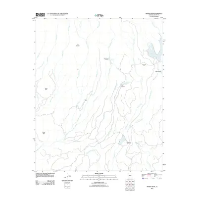
2011 Map of Bonito Rock
USGS Topo · Published 2011About this map
Big Bonito Creek and its many tributaries, including Duke Creek and Hurricane Creek, define the drainage patterns of this high-elevation landscape. The 2011 survey highlights a region dedicated to remote outposts and recreation, anchored by Duke Ranch and Reservation Ranch. The presence of several established campsites, such as Hurricane Lake Campground and Pacheta Lake Campground, suggests the importance of water access in this high country. Geological and botanical landmarks like Aspen Butte, Burnt Mountain, and the namesake Bonito Rock provide navigational anchors across the terrain. Along the eastern edge, Reservation Lake and the Deep Cienega settlement area show where water and geography have historically concentrated activity. The network of county roads, including Co HWY 8 and Co HWY 70, provides the primary modern access to these remote springs and peaks.
Find a feature on this map
29 named features on this map. Tap any name to fly to it.
Don’t see what you’re looking for? This feature index may not catch every label — zoom into the map to look around manually.
Map Details
Editions of this 2011 Bonito Rock Map
This is the sole edition of this map. No revisions or reprints were ever made.
Other maps of this area

1922 · Nutrioso
USGS Topo · 1:125,000

1954 · Clifton
USGS Topo · 1:250,000

1957 · Clifton
USGS Topo · 1:250,000

1958 · Clifton
USGS Topo · 1:250,000

1958 · Hannagan Meadow
USGS Topo · 1:62,500

1958 · Big Lake
USGS Topo · 1:62,500

1962 · Clifton
USGS Topo · 1:250,000

1967 · Marshall Butte
USGS Topo · 1:24,000
1967 · Bonito Rock
USGS Topo · 1:24,000

1967 · Odart Mtn
USGS Topo · 1:24,000