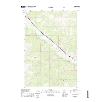
2020 Map of Bonner
USGS Topo · Published 2020About this map
The Clark Fork river serves as the primary corridor for development and transport through Missoula County, shaping the location of settlements and roads. The communities of Bonner, Piltzville, and Turah are concentrated along this valley floor, flanked by the ascending terrain of the Lolo National Forest. This 2020 survey highlights the contrast between the narrow, developed river valley and the deeply creased topography of the surrounding mountains, which are defined by numerous named drainages such as Bear Gulch, Vista Gulch, and Tule Gulch. Elevated landmarks like Bonner Mtn and Moccasin Ridge watch over the valley, while smaller tributaries including Crystal Cr and Greenough Cr carve through the forested uplands. The road network, including Fas 210 and Turah Rd, follows the natural contours of the land, providing access between the valley communities and the more isolated reaches of the surrounding forest.
Find a feature on this map
45 named features on this map. Tap any name to fly to it.
Don’t see what you’re looking for? This feature index may not catch every label — zoom into the map to look around manually.
Map Details
Editions of this 2020 Bonner Map
This is the sole edition of this map. No revisions or reprints were ever made.
Other maps of this area

1903 · Bonner
USGS Topo · 1:125,000

1947 · Butte
USGS Topo · 1:250,000

1958 · Butte
USGS Topo · 1:250,000

1959 · Cleveland Mountain
USGS Topo · 1:62,500

1959 · Ravenna
USGS Topo · 1:62,500

1960 · Butte
USGS Topo · 1:250,000

1962 · Butte
USGS Topo · 1:250,000
1964 · Southeast Missoula
USGS Topo · 1:24,000

1964 · Northeast Missoula
USGS Topo · 1:24,000
1965 · Sunflower Mountain
USGS Topo · 1:24,000