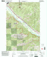
1999 Map of Bonner
USGS Topo · Published 2003About this map
Clark Fork and the Blackfoot River converge near the industrial and residential settlements of Bonner and Piltzville in this late-century topographic study. The landscape is defined by the sharp transition from the valley floor to the high elevations of the Garnet Range and Lolo National Forest. Transportation and resource extraction dominate the valley, with the McQuarrie Spur railroad line and several Gravel Pits following the river's path. Recreational access is noted at the Turah Fishing Access near the community of Turah. To the south, the terrain rises toward Moccasin Ridge and Windy Saddle, illustrating the geographic constraints that have historically shaped development in this Missoula County corridor.
Find a feature on this map
25 named features on this map. Tap any name to fly to it.
Don’t see what you’re looking for? This feature index may not catch every label — zoom into the map to look around manually.
Map Details
Editions of this 1999 Bonner Map
This is the sole edition of this map. No revisions or reprints were ever made.
Other maps of this area

1903 · Bonner
USGS Topo · 1:125,000

1947 · Butte
USGS Topo · 1:250,000

1958 · Butte
USGS Topo · 1:250,000

1959 · Cleveland Mountain
USGS Topo · 1:62,500

1959 · Ravenna
USGS Topo · 1:62,500

1960 · Butte
USGS Topo · 1:250,000

1962 · Butte
USGS Topo · 1:250,000
1964 · Southeast Missoula
USGS Topo · 1:24,000

1964 · Northeast Missoula
USGS Topo · 1:24,000
1965 · Sunflower Mountain
USGS Topo · 1:24,000