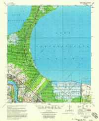
1957 Map of Bonnet Carre
USGS Topo · Published 1958About this map
Bonnet Carre Floodway dominates the mid-century landscape between Lake Maurepas and Lake Pontchartrain, serving as a critical piece of river management infrastructure. Along the Mississippi River, the map documents a transition from traditional agrarian land use to industrial development, featuring a string of riverfront settlements including Montz, Sellers, and Norco. Genealogists and local historians can locate several historic estates such as Anchor Plantation, Gypsy Plantation, and Mary Plantation, many of which were adjacent to the emerging Goodhope Oil Field and Laplace Oil Field. The Illinois Central railroad runs parallel to U.S. Highway No 51, connecting small lakeside communities like Ruddock, Wagram, and Frenier Beach. This 1957 survey captures the area just as modern flood control and oil exploration were reshaping the historic river parishes.
Find a feature on this map
46 named features on this map. Tap any name to fly to it.
Don’t see what you’re looking for? This feature index may not catch every label — zoom into the map to look around manually.
Map Details
Editions of this 1957 Bonnet Carre Map
This is the sole edition of this map. No revisions or reprints were ever made.
Other maps of this area

1891 · Hahnville
USGS Topo · 1:62,500

1891 · Spanish Fort
USGS Topo · 1:62,500

1891 · New Orleans
USGS Topo · 1:62,500

1892 · Lac Des Allemands
USGS Topo · 1:62,500

1892 · Mount Airy
USGS Topo · 1:62,500

1892 · Bonnet Carre
USGS Topo · 1:62,500

1932 · New Orleans NW
USGS Topo · 1:31,680

1932 · Hahnville NW
USGS Topo · 1:31,680

1932 · Lac Des Allemands NE
USGS Topo · 1:31,680

1932 · Hahnville NE
USGS Topo · 1:31,680