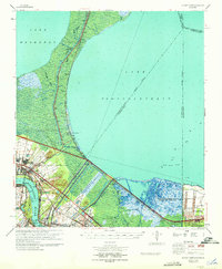
1969 Map of Bonnet Carre
USGS Topo · Published 1971About this map
The Bonnet Carre Spillway dominates this mid-century landscape, a massive flood control structure engineered between Lake Pontchartrain and the Mississippi River. This era of industrial growth is marked by the presence of the Laplace Oil and Gas Field and similar operations at Norco and Good Hope. Transportation corridors define the region's geography, with the Illinois Central Railroad and the Old Hammond Highway skirting the marshlands. Small riverfront communities like Lucy, Killona, and Montz—home to the Montz Cem—sit along the levee, contrasting with the expanding suburban developments of Carrollwood and Riverland Heights. To the east, the infrastructure of the New Orleans International Airport (Moisant Field) begins to encroach on the wetlands near Kenner.
Find a feature on this map
49 named features on this map. Tap any name to fly to it.
Don’t see what you’re looking for? This feature index may not catch every label — zoom into the map to look around manually.
Map Details
Editions of this 1969 Bonnet Carre Map
This is the sole edition of this map. No revisions or reprints were ever made.
Other maps of this area

1891 · Hahnville
USGS Topo · 1:62,500

1891 · Spanish Fort
USGS Topo · 1:62,500

1891 · New Orleans
USGS Topo · 1:62,500

1892 · Lac Des Allemands
USGS Topo · 1:62,500

1892 · Mount Airy
USGS Topo · 1:62,500

1892 · Bonnet Carre
USGS Topo · 1:62,500

1932 · New Orleans NW
USGS Topo · 1:31,680

1932 · Hahnville NW
USGS Topo · 1:31,680

1932 · Lac Des Allemands NE
USGS Topo · 1:31,680

1932 · Hahnville NE
USGS Topo · 1:31,680