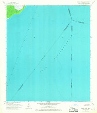
1967 Map of Bonnett Carre NE
USGS Topo · Published 1968About this map
Lake Pontchartrain dominates this hydrographic study, providing a detailed record of the offshore environment in the late 1960s. The map captures the open water and navigational hazards through the placement of numerous lights, which helped guide maritime traffic across this expansive bay. These markers were essential for vessels transiting the waters between several parish boundaries that converge here, including those of St. Charles, Tangipahoa, and St. John the Baptist Parish. The inclusion of depth curves and soundings, based on data from the Usc&GS, illustrates the underwater topography at a time when the region was actively monitored for subsidence. This documentation is a precise record of the lake's shoreline and water depths before subsequent decades of coastal change.
Find a feature on this map
6 named features on this map. Tap any name to fly to it.
Don’t see what you’re looking for? This feature index may not catch every label — zoom into the map to look around manually.
Map Details
Editions of this 1967 Bonnett Carre NE Map
This is the sole edition of this map. No revisions or reprints were ever made.
Other maps of this area

1891 · Spanish Fort
USGS Topo · 1:62,500

1892 · Bonnet Carre
USGS Topo · 1:62,500

1935 · Laplace
USGS Topo · 1:31,680

1935 · Covington
USGS Topo · 1:62,500

1935 · Ponchatoula
USGS Topo · 1:62,500

1936 · Ruddock
USGS Topo · 1:31,680

1936 · Bonnet Carre
USGS Topo · 1:62,500

1936 · Spanish Fort
USGS Topo · 1:62,500
1938 · La Branche
USGS Topo · 1:31,680
1938 · Indian Beach
USGS Topo · 1:31,680