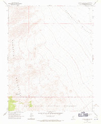
1967 Map of Bonnie Claire SE
USGS Topo · Published 1970About this map
The high-desert terrain of the Grapevine Mountains and the arid expanse of Sarcobatus Flat define this 1967 survey of the Nevada-California borderlands. Tracing through the northeastern corner of the map, the Old Railroad Grade remains a prominent physical scar on the landscape, marking the path of former industrial transit across the basin. To the southwest, the boundary of Death Valley National Monument encompasses the mountain ridges, where the rare presence of water is marked by Willow Spring and a nearby Water Tank. The mapping emphasizes the isolation of this corner of Nye County, focusing on the topographic relationship between the steep mountain slopes and the sweeping, low-lying flats used for transportation in the early twentieth century.
Find a feature on this map
11 named features on this map. Tap any name to fly to it.
Don’t see what you’re looking for? This feature index may not catch every label — zoom into the map to look around manually.
Map Details
Editions of this 1967 Bonnie Claire SE Map
2 editions found
Other maps of this area

1908 · Kawich
USGS Topo · 1:250,000

1908 · Lida
USGS Topo · 1:250,000

1908 · Furnace Creek
USGS Topo · 1:250,000

1908 · Ballarat
USGS Topo · 1:250,000

1910 · Furnace Creek
USGS Topo · 1:250,000

1913 · Lida
USGS Topo · 1:250,000

1913 · Ballarat
USGS Topo · 1:250,000

1942 · Tolicha Peak
USGS Topo · 1:125,000

1942 · Bullfrog
USGS Topo · 1:125,000

1948 · Death Valley
USGS Topo · 1:250,000