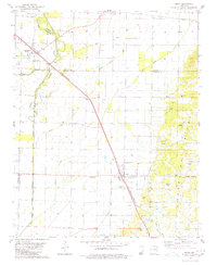
1980 Map of Bono
USGS Topo · Published 1980About this map
Crowleys Ridge rises above the flatlands of the Mississippi embayment, defining the eastern portion of this 1980 survey near the borders of Greene, Lawrence, and Craighead counties. The landscape is a study in contrasting drainage and elevation, where the Cache River and its associated wetlands like Bohanan Slough and Whaley Slough weave through a network of agricultural ditches. The town of Bono and the small settlement of Sedgwick serve as the primary hubs, linked by the diagonal path of the St Louis - San Francisco railroad. This rail line also passes through the minor stop of Pauls Switch, reflecting the area's historical reliance on timber and rail transport. For those researching local heritage, the map reveals numerous rural landmarks including the Old Military Cem, Bells Chapel Ch, and Love Cem, alongside several gravel pits that indicate the local extractive industry.
Find a feature on this map
33 named features on this map. Tap any name to fly to it.
Don’t see what you’re looking for? This feature index may not catch every label — zoom into the map to look around manually.
Map Details
Editions of this 1980 Bono Map
This is the sole edition of this map. No revisions or reprints were ever made.
Other maps of this area

1932 · Walnut Ridge
USGS Topo · 1:62,500

1935 · Sedgwick
USGS Topo · 1:62,500

1935 · Walnut Ridge
USGS Topo · 1:62,500

1939 · Jonesboro
USGS Topo · 1:62,500

1940 · Gainesville
USGS Topo · 1:62,500

1953 · Memphis
USGS Topo · 1:250,000

1956 · Memphis
USGS Topo · 1:250,000

1957 · Poplar Bluff
USGS Topo · 1:250,000

1958 · Jonesboro
USGS Topo · 1:62,500

1958 · Gainesville
USGS Topo · 1:62,500