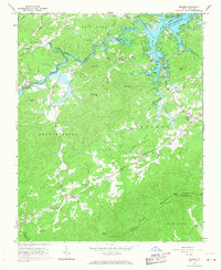
1966 Map of Boomer
USGS Topo · Published 1968About this map
The W Kerr Scott Reservoir dominates the northern landscape, where the waters of the Yadkin River and Lewis Fork meet. This mid-1960s survey captures a transition in Wilkes County topography, showing the newly created reservoir's shoreline along with established public use areas like the Smitheys Creek Public Use Area and the Warrior Creek Boat Ramp. South of the water, the terrain rises into the Brushy Mountains, marked by peaks such as Stoneman Mtn and Mars Mtn. Rural life centers on small crossroads like Ferguson and Boomer, supported by local institutions like the Boomer-Ferguson Sch and Beaver Creek Ch. The map provides a detailed view of the winding mountain roads, including Dula Road, and tracing the county lines where Wilkes meets Alexander and Caldwell counties near Ellendale and Beaver.
Find a feature on this map
47 named features on this map. Tap any name to fly to it.
Don’t see what you’re looking for? This feature index may not catch every label — zoom into the map to look around manually.
Map Details
Editions of this 1966 Boomer Map
This is the sole edition of this map. No revisions or reprints were ever made.
Other maps of this area

1889 · Wilkesboro
USGS Topo · 1:125,000

1891 · Wilkesboro
USGS Topo · 1:125,000

1895 · Hickory
USGS Topo · 1:125,000

1953 · Charlotte
USGS Topo · 1:250,000

1953 · Winston-Salem
USGS Topo · 1:250,000

1954 · Charlotte
USGS Topo · 1:250,000

1955 · Winston-Salem
USGS Topo · 1:250,000

1960 · Charlotte
USGS Topo · 1:250,000

1962 · Winston-Salem
USGS Topo · 1:250,000

1962 · Charlotte
USGS Topo · 1:250,000