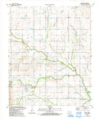
1991 Map of Boone
USGS Topo · Published 1992About this map
East Cache Creek and its various tributaries, including Tahoe Creek and Mission Creek, define the landscape of this portion of Caddo County in the early 1990s. The area maintains a rural, production-oriented character, with an active Oil Field indicated by several scattered Oil Wells. Local community life is centered around the small settlements of Boone, Hatchetville, and Broxton. Cultural and historical landmarks are preserved through several sites, notably the Comanche Indian Cem and Cache Creek Cem located south of the main waterways. Genealogists and historians may also find interest in the proximity of local congregations at Bellview Ch and Memorial Ch, while the inclusion of the Apache Downs Racetrack adds a specific recreational dimension to the documented local infrastructure.
Find a feature on this map
21 named features on this map. Tap any name to fly to it.
Don’t see what you’re looking for? This feature index may not catch every label — zoom into the map to look around manually.
Map Details
Editions of this 1991 Boone Map
This is the sole edition of this map. No revisions or reprints were ever made.
Other maps of this area

1949 · Elgin
USGS Topo · 1:24,000

1950 · Saddle Mountain
USGS Topo · 1:62,500

1951 · Fort Cobb
USGS Topo · 1:62,500

1955 · Lawton
USGS Topo · 1:250,000

1955 · Clinton
USGS Topo · 1:250,000

1956 · Alden
USGS Topo · 1:24,000

1956 · Boone
USGS Topo · 1:24,000

1956 · Elgin
USGS Topo · 1:24,000

1956 · Richards Spur
USGS Topo · 1:24,000

1956 · Meers
USGS Topo · 1:24,000