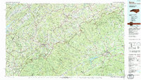
1985 Map of Boone
USGS Topo · Published 1986About this map
Appalachian State University anchors the town of Boone in this mid-1980s topographic portrait, where the High Country of North Carolina meets the Tennessee border. The landscape is defined by the winding Blue Ridge Parkway, which connects several large conservation areas including Julian Price Memorial Park, Moses H. Cone Memorial Park, and Doughton Park. To the west, the Stone Mountains and Iron Mountains dominate the horizon, leading toward the waters of Watauga Lake.
Find a feature on this map
262 named features on this map. Tap any name to fly to it.
Don’t see what you’re looking for? This feature index may not catch every label — zoom into the map to look around manually.
Map Details
Editions of this 1985 Boone Map
2 editions found
Other maps of this area

1889 · Hillsville
USGS Topo · 1:125,000

1889 · Wytheville
USGS Topo · 1:125,000

1889 · Wilkesboro
USGS Topo · 1:125,000

1891 · Roan Mountain
USGS Topo · 1:125,000

1891 · Abingdon
USGS Topo · 1:125,000

1891 · Wilkesboro
USGS Topo · 1:125,000

1891 · Yadkinville
USGS Topo · 1:125,000

1892 · Hillsville
USGS Topo · 1:125,000

1892 · Wytheville
USGS Topo · 1:125,000

1893 · Cranberry
USGS Topo · 1:125,000