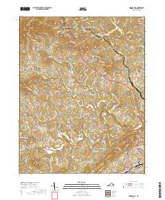
2019 Map of Boones Mill
USGS Topo · Published 2019About this map
Boones Mill and the surrounding Franklin County landscape are defined by a network of family-named cemeteries and small settlements. The topography is anchored by heights such as Cahas Mtn and Bunker Hill, with numerous drainages like Magodee Cr and Teels Cr cutting through the terrain. The community structure is evident in the cluster of small locales including Gogginsville, Dugwell, and Helm, many of which are centered around ancestral burial grounds such as Pate Cem, Abshire Cem, and the Webster Cem. To the south, the northern reaches of Rocky Mount appear near the W N Angle Memorial Bridge and Powder Mill Cr. This survey illustrates the persistent rural character of the region, where modern road networks like Us HWY 220 intersect with long-established landmarks like Antioch Cem and the Mountain View Burial Park, offering a detailed view of the area's genealogical and geographic layout.
Find a feature on this map
64 named features on this map. Tap any name to fly to it.
Don’t see what you’re looking for? This feature index may not catch every label — zoom into the map to look around manually.
Map Details
Editions of this 2019 Boones Mill Map
This is the sole edition of this map. No revisions or reprints were ever made.
Other maps of this area

1890 · Roanoke
USGS Topo · 1:125,000

1890 · Christiansburg
USGS Topo · 1:125,000

1891 · Roanoke
USGS Topo · 1:125,000

1925 · Rocky Mount
USGS Topo · 1:48,000

1927 · Rocky Mount
USGS Topo · 1:62,500

1944 · Rocky Mount
USGS Topo · 1:62,500

1947 · Roanoke
USGS Topo · 1:250,000

1950 · Elliston
USGS Topo · 1:62,500

1951 · Boones Mill
USGS Topo · 1:62,500

1953 · Winston-Salem
USGS Topo · 1:250,000