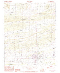
1983 Map of Booneville
USGS Topo · Published 1983About this map
The town of Booneville sits south of Booneville Mountain, serving as a hub for this Logan County region in the early 1980s. The landscape is defined by long, parallel ridges like Backbone Mountain and Pisgah Mountain that partition the land into distinct agricultural valleys, including Fox Valley and Ferguson Valley. This survey captures the rural layout of the time, where small settlements like Chismville and Brownsville are connected by a network of roads following the natural contours of the terrain.
Find a feature on this map
52 named features on this map. Tap any name to fly to it.
Don’t see what you’re looking for? This feature index may not catch every label — zoom into the map to look around manually.
Map Details
Editions of this 1983 Booneville Map
This is the sole edition of this map. No revisions or reprints were ever made.
Other maps of this area

1887 · Magazine Mountain #2
USGS Topo · 1:62,500

1887 · Magazine Mountain #3
USGS Topo · 1:62,500

1887 · Magazine Mountain
USGS Topo · 1:62,500

1890 · Magazine Mountain
USGS Topo · 1:125,000

1890 · Fort Smith
USGS Topo · 1:125,000

1906 · Lavaca
USGS Topo · 1:62,500

1906 · Barber
USGS Topo · 1:62,500

1934 · Booneville
USGS Topo · 1:48,000

1939 · Booneville
USGS Topo · 1:62,500

1943 · Fort Smith
USGS Topo · 1:125,000