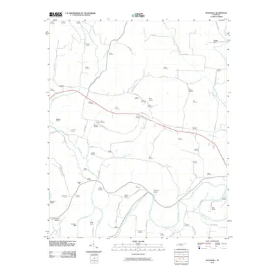
2010 Map of Boonshill
USGS Topo · Published 2010About this map
Boonshill Cemetery and numerous family burying grounds are scattered across this Lincoln County landscape, reflecting generations of settlement along the complex drainage of the Elk River. The terrain is defined by a series of narrow hollows such as Sawyer Hollow and Barnes Hollow, which carve into the higher elevations of Hickory Ridge and Sugg Hill. Winding watercourses like Swan Creek and Little Swan Creek dictate the placement of local roads, including Delina Boonshill Rd and HugHEY Rd. Near the southern edge, the Elk River makes a sharp turn at Hovis Bend, passing below the prominent Whitaker Bluff. This map provides significant genealogical value, identifying dozens of small cemeteries like the McDaniel Cemetery, Childress Cemetery, and Martin-Chitwood Cemetery that might otherwise be overlooked in modern records.
Find a feature on this map
97 named features on this map. Tap any name to fly to it.
Don’t see what you’re looking for? This feature index may not catch every label — zoom into the map to look around manually.
Map Details
Editions of this 2010 Boonshill Map
This is the sole edition of this map. No revisions or reprints were ever made.
Other maps of this area

1936 · Cornersville
USGS Topo · 1:24,000

1936 · Taft
USGS Topo · 1:24,000

1936 · Belleville
USGS Topo · 1:24,000

1936 · Boonshill
USGS Topo · 1:24,000

1936 · Petersburg
USGS Topo · 1:24,000

1936 · Lincoln
USGS Topo · 1:24,000

1936 · Frankewing
USGS Topo · 1:24,000

1936 · Fayetteville
USGS Topo · 1:24,000

1936 · Dellrose
USGS Topo · 1:24,000

1944 · Shelbyville
USGS Topo · 1:100,000