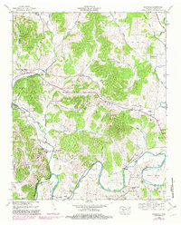
1949 Map of Boonshill
USGS Topo · Published 1982About this map
Swan Creek and its many tributaries carve a path through this section of Lincoln County, defining the settlement patterns of the mid-twentieth century. The landscape is dotted with small communities like Boonshill and Hughey, where local life centered around rural gathering places such as East Cyrunton Church and Antioch Ch. Many family names are preserved in the geography through features like Cathey Cem and Crawford Cem, providing a direct link for genealogists studying the area's heritage.
Find a feature on this map
52 named features on this map. Tap any name to fly to it.
Don’t see what you’re looking for? This feature index may not catch every label — zoom into the map to look around manually.
Map Details
Editions of this 1949 Boonshill Map
This is the sole edition of this map. No revisions or reprints were ever made.
Other maps of this area

1936 · Cornersville
USGS Topo · 1:24,000

1936 · Taft
USGS Topo · 1:24,000

1936 · Belleville
USGS Topo · 1:24,000

1936 · Boonshill
USGS Topo · 1:24,000

1936 · Petersburg
USGS Topo · 1:24,000

1936 · Lincoln
USGS Topo · 1:24,000

1936 · Frankewing
USGS Topo · 1:24,000

1936 · Fayetteville
USGS Topo · 1:24,000

1936 · Dellrose
USGS Topo · 1:24,000

1944 · Shelbyville
USGS Topo · 1:100,000