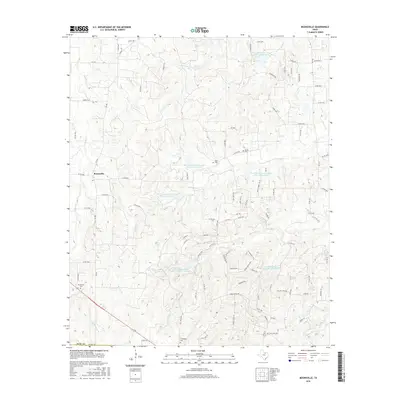
2016 Map of Boonsville
USGS Topo · Published 2016About this map
Boonsville serves as the primary settlement hub for this corner of Wise County, where rural life is shaped by a dense network of farm-to-market roads and seasonal drainages. The landscape is defined by the legacy of mid-century land management, evidenced by several water control structures including Soil Conservation Service Site 12 Reservoir and Soil Conservation Service Site 1 Reservoir. These reservoirs are integrated into the natural hydrology of streams like Garrett Cr and Willow Cr. Genealogy is well-represented through scattered historical burial grounds such as Grandview Cem, Gillie Cem, and Friendship Cem. The presence of Indian Spring and numerous family-named local roads, such as Carpenter Rd and Shawn Rd, reflect the localized ranching and farming heritage that persists in this region of North Central Texas.
Find a feature on this map
98 named features on this map. Tap any name to fly to it.
Don’t see what you’re looking for? This feature index may not catch every label — zoom into the map to look around manually.
Map Details
Editions of this 2016 Boonsville Map
This is the sole edition of this map. No revisions or reprints were ever made.
Other maps of this area

1891 · Weatherford
USGS Topo · 1:125,000

1893 · Weatherford
USGS Topo · 1:125,000

1930 · Boyd
USGS Topo · 1:62,500

1932 · Springtown
USGS Topo · 1:62,500

1954 · Dallas
USGS Topo · 1:250,000

1954 · Sherman
USGS Topo · 1:250,000

1958 · Dallas
USGS Topo · 1:250,000

1958 · Sherman
USGS Topo · 1:250,000

1958 · Springtown
USGS Topo · 1:24,000
1959 · Adell
USGS Topo · 1:24,000