
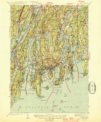
1944 Map of Boothbay
USGS Topo · Published 1944About this map
The tidal rivers and rocky peninsulas of Lincoln County dominate this 1941 survey, showing the intricate coastline of Midcoast Maine during the World War II era. Wiscasset serves as a primary hub where the Maine Central railroad crosses the Sheepscot River, while further south, the harbor towns like Boothbay Harbor and Southport reflect the region's deep maritime roots. The map details a landscape of narrow inlets and islands, from Barters Island to the tip of Newagen. Small inland settlements and crossroads such as Boothbay Center and East Edgecomb are connected by a network of early state roads, including Route 1. Genealogists will find numerous family-named landmarks and local burial grounds, such as Woodlawn Cem and Oaklawn Cem, alongside neighborhood institutions like Lincoln Sch and Gladstone Sch. The detailed rendering of Pemaquid Harbor and Johns Bay illustrates the complex seafaring geography of this historic coastal stretch.
Find a feature on this map
240 named features on this map. Tap any name to fly to it.
Don’t see what you’re looking for? This feature index may not catch every label — zoom into the map to look around manually.
Map Details
Editions of this 1944 Boothbay Map
2 editions found
Other maps of this area

1892 · Gardiner
USGS Topo · 1:62,500

1893 · Small Point
USGS Topo · 1:62,500

1893 · Wiscasset
USGS Topo · 1:62,500

1893 · Boothbay
USGS Topo · 1:62,500

1894 · Bath
USGS Topo · 1:62,500

1904 · Monhegan
USGS Topo · 1:62,500

1906 · Monhegan
USGS Topo · 1:62,500

1913 · Waldoboro
USGS Topo · 1:48,000

1915 · Waldoboro
USGS Topo · 1:62,500

1919 · Small Point
USGS Topo · 1:62,500