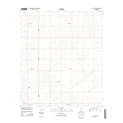
2013 Map of Bootleg Ridge
USGS Topo · Published 2013About this map
Bootleg Ridge rises above the southeastern New Mexico landscape, marking a topographically distinct area along the border of Eddy and Lea counties. This 2013 survey illustrates a landscape primarily defined by energy extraction and cattle ranching infrastructure. Extensive fossil fuel activity is documented through the presence of the Sand Dunes Oil Field in the west and the Triste Draw Oil Field to the southeast. These industrial zones are connected by a network of rural routes including Red Rd, Mills Ranch Rd, and Co Road 31. Water management in this arid environment is highlighted by features like Hayfield Tank, while the southern edge of the quadrangle is traversed by NM-128. The map provides a precise view of the Public Land Survey System grid, detailing sections across multiple townships such as t23s r32e.
Find a feature on this map
16 named features on this map. Tap any name to fly to it.
Don’t see what you’re looking for? This feature index may not catch every label — zoom into the map to look around manually.
Map Details
Editions of this 2013 Bootleg Ridge Map
This is the sole edition of this map. No revisions or reprints were ever made.
Other maps of this area

1939 · Nash Draw
USGS Topo · 1:62,500

1943 · Nash Draw
USGS Topo · 1:62,500

1954 · Hobbs
USGS Topo · 1:250,000

1958 · Hobbs
USGS Topo · 1:250,000

1963 · Hat Mesa
USGS Topo · 1:62,500
1968 · Big Sinks
USGS Topo · 1:24,000

1973 · Bell Lake
USGS Topo · 1:24,000

1973 · Paduca Breaks NW
USGS Topo · 1:24,000

1978 · Jal
USGS Topo · 1:100,000
1984 · Tip Top Wells
USGS Topo · 1:24,000