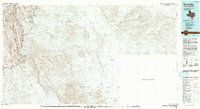
1984 Map of Boquillas
USGS Topo · Published 1993About this map
The Rio Grande carves a sharp, winding boundary through this 1980s landscape, separating the United States of America from the Estados Unidos Mexicanos. This arid region in Brewster County is defined by the high elevations of the Sierra del Carmen and the Sierra del Caballo Muerto, which dominate the western portion of the sheet. Most of the terrain is protected land, including the eastern reaches of Big Bend National Park and the Black Gap State Wildlife Management Area.
Find a feature on this map
19 named features on this map. Tap any name to fly to it.
Don’t see what you’re looking for? This feature index may not catch every label — zoom into the map to look around manually.
Map Details
Editions of this 1984 Boquillas Map
2 editions found
Other maps of this area

1903 · Chisos Mountains
USGS Topo · 1:125,000

1905 · Chisos Mountains
USGS Topo · 1:125,000

1917 · Bone Spring
USGS Topo · 1:62,500

1918 · Reagan Canyon
USGS Topo · 1:62,500

1918 · Bone Spring
USGS Topo · 1:125,000

1918 · Bone Spring
USGS Topo · 1:62,500

1919 · Maravillas Canyon
USGS Topo · 1:62,500

1920 · Bone Spring
USGS Topo · 1:62,500

1930 · Stillwell Creek
USGS Topo · 1:62,500

1958 · Eagle Pass
USGS Topo · 1:250,000