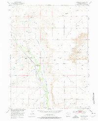
1953 Map of Bordeaux
USGS Topo · Published 1977About this map
Chugwater Creek winds through this section of Platte County, defining a fertile corridor amidst the surrounding Slater Flats and Goshen Hole. The map preserves a high concentration of established cattle operations, including the Wedemeyer Ranch, Phillippi Ranch, L D Ranch, and M Bar Ranch, illustrating the dominance of ranching in this Wyoming landscape. Central to the area's history is the settlement of Bordeaux, situated near the Colorado and Southern (Burlington) railroad line.
Find a feature on this map
19 named features on this map. Tap any name to fly to it.
Don’t see what you’re looking for? This feature index may not catch every label — zoom into the map to look around manually.
Map Details
Editions of this 1953 Bordeaux Map
2 editions found
Other maps of this area

1896 · Hartville
USGS Topo · 1:125,000

1901 · Hartville
USGS Topo · 1:125,000

1951 · Antelope Gap
USGS Topo · 1:24,000
1951 · Wheatland
USGS Topo · 1:24,000

1951 · Eagles Nest
USGS Topo · 1:24,000

1953 · Double L Ranch
USGS Topo · 1:24,000

1953 · Chugwater
USGS Topo · 1:24,000

1953 · Ferguson Corner
USGS Topo · 1:24,000

1953 · Bordeaux
USGS Topo · 1:24,000

1954 · Torrington
USGS Topo · 1:250,000