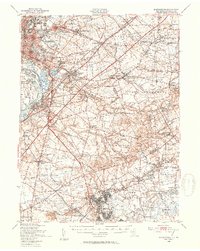
1948 Map of Bordentown
USGS Topo · Published 1954About this map
The Delaware River serves as the western anchor of this landscape, where the Pennsylvania Railroad and the Delaware & Raritan Canal converge near Bordentown. The postwar expansion of the late 1940s is evident in the emerging suburban clusters of Trenton Gardens, De Cou Village, and The Orchards, while the newly added New Jersey Turnpike cuts a modern path through traditional farming townships. To the south, the massive footprint of Fort Dix and Mc Guire Air Force Base dominates the terrain, marking a significant military presence. Local industry and historic transit points are scattered throughout, from the milling sites at Hutchinson Mills and Carsons Mills to the Pa Maritime Academy on the riverbank. This survey captures a pivotal moment when the rural character of Hamilton and Chesterfield began to meet the rapid infrastructure growth of the mid-20th century.
Find a feature on this map
123 named features on this map. Tap any name to fly to it.
Don’t see what you’re looking for? This feature index may not catch every label — zoom into the map to look around manually.
Map Details
Editions of this 1948 Bordentown Map
2 editions found
Other maps of this area

1884 · Whitings
USGS Topo · 1:62,500

1888 · Bordentown
USGS Topo · 1:62,500

1888 · Pemberton
USGS Topo · 1:62,500

1888 · New Brunswick
USGS Topo · 1:62,500

1888 · Mount Holly
USGS Topo · 1:62,500

1888 · Princeton
USGS Topo · 1:62,500

1888 · Cassville
USGS Topo · 1:62,500

1888 · Whitings
USGS Topo · 1:62,500

1890 · Lambertville
USGS Topo · 1:62,500

1890 · Burlington
USGS Topo · 1:62,500