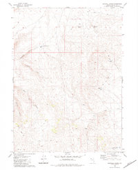
1980 Map of Bordwell Spring
USGS Topo · Published 1984About this map
Bordwell Spring and its adjacent Water Tanks represent a critical water resource in this arid high-desert landscape of northwestern Nevada. The map details a network of canyons including Bordwell Canyon, Well Canyon, and Cockrell Canyon that drain toward the southwest, while Cherry Mountain rises as a prominent landmark in the southwestern corner.
Find a feature on this map
17 named features on this map. Tap any name to fly to it.
Don’t see what you’re looking for? This feature index may not catch every label — zoom into the map to look around manually.
Map Details
Editions of this 1980 Bordwell Spring Map
2 editions found
Other maps of this area

1889 · Long Valley
USGS Topo · 1:250,000

1954 · Vya
USGS Topo · 1:250,000

1958 · Vya
USGS Topo · 1:250,000

1962 · Vya
USGS Topo · 1:250,000

1978 · Hart Mountain
USGS Topo · 1:24,000
1979 · Wall Canyon Reservoir
USGS Topo · 1:24,000
1979 · Boulder Mtn.
USGS Topo · 1:24,000
1979 · Pinto Springs
USGS Topo · 1:24,000
1979 · Chester Lyons Spring
USGS Topo · 1:24,000
1980 · Fox Mountain
USGS Topo · 1:24,000