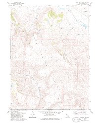
1979 Map of Boulder Mtn.
USGS Topo · Published 1980About this map
Home Camp stands as a focal point in this high-desert landscape of northwestern Nevada, situated near the northern reach of the Hay Canyon Range. This 1970s survey captures a territory defined by its critical water sources, essential for ranching and survival in the Great Basin. A network of springs such as Horse Canyon Springs, Coyote Spring, and Cottonwood Spring are mapped alongside livestock-oriented features like Sheep Trough Tank and Jack Reservoir. The complex topography includes the prominent heights of Boulder Mountain and the broad expanse of Mare Pasture. In the southwest, Mahogany Lake and Indian Valley mark the transition toward more varied terrain. Remote access is indicated by various Jeep Trails, showing the era's reliance on rugged vehicle paths to connect isolated camps and watering holes across the Washoe County backcountry.
Find a feature on this map
23 named features on this map. Tap any name to fly to it.
Don’t see what you’re looking for? This feature index may not catch every label — zoom into the map to look around manually.
Map Details
Editions of this 1979 Boulder Mtn. Map
2 editions found
Other maps of this area

1889 · Long Valley
USGS Topo · 1:250,000

1954 · Vya
USGS Topo · 1:250,000

1958 · Vya
USGS Topo · 1:250,000

1962 · Vya
USGS Topo · 1:250,000
1979 · Powers Well
USGS Topo · 1:24,000
1979 · Boulder Lake
USGS Topo · 1:24,000
1979 · Hays Canyon
USGS Topo · 1:24,000
1979 · Wall Canyon Reservoir
USGS Topo · 1:24,000
1979 · Pinto Springs
USGS Topo · 1:24,000
1980 · Big Hat Mtn
USGS Topo · 1:24,000