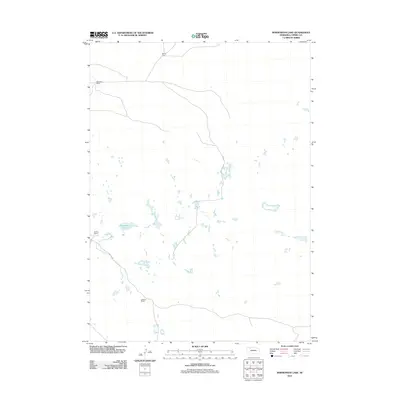
2011 Map of Bornemann Lake
USGS Topo · Published 2011About this map
Bornemann Lake lies at the heart of this Cherry County landscape, characterized by a complex network of ephemeral water bodies and isolated ranching outposts. The 2011 survey reveals a vast, sparsely populated terrain where livestock operations form the primary human footprint. Large agricultural holdings including Burton Ranch in the north and Baseggio Ranch to the west define the local geography, connected by a simple network of rural roads. The southern portion of the sheet is marked by Tailbone Ranch, while Zlomke Ranch sits near the western edge. This map provides an essential record of the contemporary Sandhills cattle-raising tradition, showing how named homesteads serve as the primary landmarks in a region dominated by countless small basins and wetlands.
Find a feature on this map
5 named features on this map. Tap any name to fly to it.
Don’t see what you’re looking for? This feature index may not catch every label — zoom into the map to look around manually.
Map Details
Editions of this 2011 Bornemann Lake Map
This is the sole edition of this map. No revisions or reprints were ever made.
Other maps of this area

1950 · Irwin
USGS Topo · 1:62,500

1951 · Irwin
USGS Topo · 1:62,500

1951 · Gypsy Valley
USGS Topo · 1:62,500

1951 · Merriman
USGS Topo · 1:62,500

1951 · Merriman 4
USGS Topo · 1:62,500

1957 · Valentine
USGS Topo · 1:250,000

1959 · Valentine
USGS Topo · 1:250,000

1985 · Cody
USGS Topo · 1:100,000
1990 · Wild Mare Lake SW
USGS Topo · 1:24,000
1990 · North Valley
USGS Topo · 1:24,000