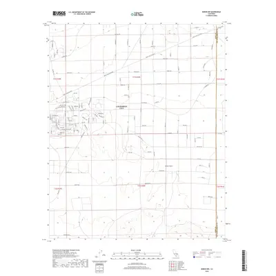
2018 Map of Boron NW
USGS Topo · Published 2018About this map
California City expands across the high desert floor in this 2018 record of eastern Kern County. The map reveals the ambitious residential grid characteristic of this master-planned community, where long thoroughfares like Purdue Blvd and Twenty Mule Team Pkwy stretch across the arid landscape. The residential core shows a dense network of suburban streets such as Sierra Vista Dr and Playa Del Sol North Dr, contrasting sharply with the undeveloped expanses of the surrounding Mojave Desert. This survey illustrates the specific geometry of a desert city designed for a future that remains partially realized, providing a clear view of the municipal boundaries and naming patterns established by the turn of the 21st century. Researchers can trace the intersection of modern infrastructure with the historical path suggested by names like the Twenty Mule Team Parkway.
Find a feature on this map
50 named features on this map. Tap any name to fly to it.
Don’t see what you’re looking for? This feature index may not catch every label — zoom into the map to look around manually.
Map Details
Editions of this 2018 Boron NW Map
This is the sole edition of this map. No revisions or reprints were ever made.
Other maps of this area

1903 · Randsburg
USGS Topo · 1:62,500

1911 · Randsburg
USGS Topo · 1:62,500

1912 · Randsburg
USGS Topo · 1:62,500

1915 · Searles Lake
USGS Topo · 1:250,000

1943 · Saltdale
USGS Topo · 1:62,500

1943 · Castle Butte
USGS Topo · 1:62,500

1947 · Castle Butte
USGS Topo · 1:50,000

1947 · Johannesburg SE
USGS Topo · 1:25,000
1947 · Castle Butte SE
USGS Topo · 1:24,000

1947 · Johannesburg SW
USGS Topo · 1:24,000