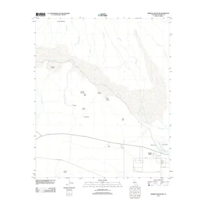
2012 Map of Borrego Mountain
USGS Topo · Published 2012About this map
Ocotillo Wells serves as the primary outpost in this arid landscape, situated at the junction of the Borrego Springs Rd and the Old Kane Springs Rd. The town's layout, including streets like Split Mountain Rd, centers around the Ocotillo Airport and the nearby Benson Lake. This region of San Diego County is defined by its complex drainage network, where numerous washes such as Rainbow Wash, Palo Verde Wash, and Fault Wash dissect the terrain of the Borrego Badlands. To the west, the prominent elevations of Borrego Mountain—comprised of West Butte and East Butte—rise above the Borrego Valley. The map details the transition into the Anza-Borrego Desert State Park, identifying specific natural landmarks like The Slot and the Cactus Garden, which highlight the distinct geomorphology and flora of the Colorado Desert at the start of the 21st century.
Find a feature on this map
32 named features on this map. Tap any name to fly to it.
Don’t see what you’re looking for? This feature index may not catch every label — zoom into the map to look around manually.
Map Details
Editions of this 2012 Borrego Mountain Map
This is the sole edition of this map. No revisions or reprints were ever made.
Other maps of this area

1904 · Indio
USGS Topo · 1:125,000

1931 · Vallecito
USGS Topo · 1:125,000

1939 · Borrego
USGS Topo · 1:62,500

1941 · Clark Lake
USGS Topo · 1:62,500

1942 · Barrel Spring
USGS Topo · 1:62,500

1942 · Agua Dulce
USGS Topo · 1:62,500

1942 · Clark Lake
USGS Topo · 1:62,500

1942 · Borego
USGS Topo · 1:62,500

1943 · Vallecito
USGS Topo · 1:125,000

1944 · Agua Dulce
USGS Topo · 1:62,500