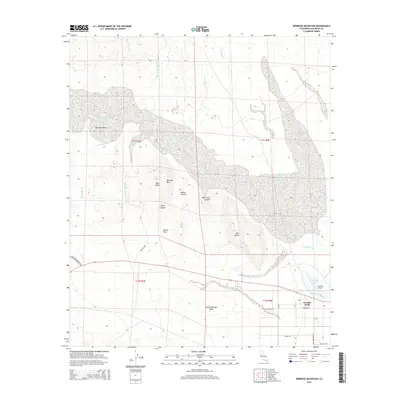
2015 Map of Borrego Mountain
USGS Topo · Published 2015About this map
Borrego Mtn rises as a central topographic anchor in this San Diego County desert landscape, flanked by the distinct peaks of West Butte and East Butte. The terrain is defined by a complex network of arid drainages, including the Hills of the Moon Wash, Third Wash, and Fault Wash, which illustrate the region's erosional patterns and geological activity. Near the southern boundary, the settlement of Ocotillo Wells provides a hub for local transit and recreation, situated at the junction of Borrego Springs Rd and Vallecito Rd. This area reflects the intersection of desert aviation and exploration, centered on the Ocotillo Airport and the seasonal Benson Lake. The map reveals a land shaped by water and wind, from the confined depths of Hawk Canyon to the shifting geography of Blow Sand Canyon, providing essential context for those studying the Colorado Desert's physical evolution.
Find a feature on this map
32 named features on this map. Tap any name to fly to it.
Don’t see what you’re looking for? This feature index may not catch every label — zoom into the map to look around manually.
Map Details
Editions of this 2015 Borrego Mountain Map
This is the sole edition of this map. No revisions or reprints were ever made.
Other maps of this area

1904 · Indio
USGS Topo · 1:125,000

1931 · Vallecito
USGS Topo · 1:125,000

1939 · Borrego
USGS Topo · 1:62,500

1941 · Clark Lake
USGS Topo · 1:62,500

1942 · Barrel Spring
USGS Topo · 1:62,500

1942 · Agua Dulce
USGS Topo · 1:62,500

1942 · Clark Lake
USGS Topo · 1:62,500

1942 · Borego
USGS Topo · 1:62,500

1943 · Vallecito
USGS Topo · 1:125,000

1944 · Agua Dulce
USGS Topo · 1:62,500