
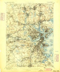
1893 Map of Boston
USGS Topo · Published 1893About this map
Boston and its surrounding townships are shown here during a period of rapid suburban expansion and coastal industrialization. The landscape is defined by the winding Charles River and a dense network of transit, including the Boston and Lowell Railroad and the Old Colony Railroad, which linked the city center to burgeoning neighborhoods like Jamaica Plain and Hyde Park. Along the harbor, the Navy Yard and Fort Winthrop stand as prominent maritime landmarks, while the coastline shows significant commercial development at Commercial Point and Squantum. To the north, the Middlesex Fells area remains a notable expanse of wooded terrain, contrasting with the tightly packed street grids of Charlestown and Everett. Genealogists and historians will find value in the specific placement of local institutions, from the Theological Seminary in Newton to the U.S. Marine Hospital near the Chelsea border, illustrating the late-nineteenth-century civic character of the region.
Find a feature on this map
185 named features on this map. Tap any name to fly to it.
Don’t see what you’re looking for? This feature index may not catch every label — zoom into the map to look around manually.
Map Details
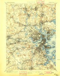
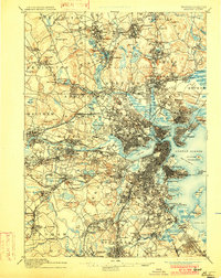
Editions of this 1893 Boston Map
4 editions found
Other maps of this area

1885 · Abington
USGS Topo · 1:62,500

1886 · Lawrence
USGS Topo · 1:62,500

1886 · Dedham
USGS Topo · 1:62,500

1886 · Lowell
USGS Topo · 1:62,500

1886 · Framingham
USGS Topo · 1:62,500

1887 · Franklin
USGS Topo · 1:62,500

1888 · Lawrence
USGS Topo · 1:62,500

1888 · Salem
USGS Topo · 1:62,500

1888 · Abington
USGS Topo · 1:62,500

1889 · Franklin
USGS Topo · 1:62,500