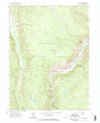
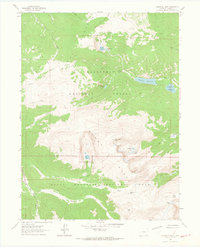
1962 Map of Boston Peak
USGS Topo · Published 1969About this map
Roosevelt National Forest dominates this high-altitude landscape in Larimer County, where the Cache La Poudre River carves a deep valley through the terrain. In the early 1960s, this area served as a focal point for mountain recreation and early water management, evidenced by the tunnel system near Emerald Lake and the concentration of visitor facilities. Small settlements like Spencer Heights and Red Place provided outposts for travelers, while the Sportsman Lodge and a local Trading Post anchored the community near the riverbanks. The mapping of Boston Peak and Elephant Mountain highlights the prominence of the Green Ridge formation. A network of Trails and Jeep Trails provides access to remote water bodies like Lily Pond Lake and Twin Lakes, illustrating the seasonal use patterns of the forest before modern expansions.
Find a feature on this map
37 named features on this map. Tap any name to fly to it.
Don’t see what you’re looking for? This feature index may not catch every label — zoom into the map to look around manually.
Map Details
Editions of this 1962 Boston Peak Map
4 editions found
Other maps of this area

1916 · Home
USGS Topo · 1:125,000

1920 · Home
USGS Topo · 1:125,000

1954 · Greeley
USGS Topo · 1:250,000

1957 · Greeley
USGS Topo · 1:250,000

1958 · Greeley
USGS Topo · 1:250,000

1961 · Greeley
USGS Topo · 1:250,000
1962 · Clark Peak
USGS Topo · 1:24,000

1962 · Boston Peak
USGS Topo · 1:24,000
1962 · Comanche Peak
USGS Topo · 1:24,000

1962 · Kinikinik
USGS Topo · 1:24,000