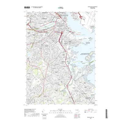
2018 Map of Boston South
USGS Topo · Published 2018About this map
The Charles River serves as the central artery for this densely populated urban landscape, separating the intellectual hubs of Cambridge and Somerville from the historic neighborhoods of Back Bay and Roxbury. Modern infrastructure like the Leonard P Zakim Bunker Hill Bridge stands alongside sites of deep historical significance, including the Granary Burying Ground and Boston National Historical Park. Further south, the map details the transition from industrial centers like Lower Mills and Milton Upper Mills to the expansive coastal areas around Dorchester Bay and Quincy. The shoreline is defined by notable landmarks such as Fort Independence on Castle Island and the marshes of the Squantum Peninsula. From the colonial-era Copps Hill Burial Ground to the prestigious campuses of Harvard University and Mit, the map documents the layer upon layer of development that characterizes the modern city.
Find a feature on this map
166 named features on this map. Tap any name to fly to it.
Don’t see what you’re looking for? This feature index may not catch every label — zoom into the map to look around manually.
Map Details
Editions of this 2018 Boston South Map
This is the sole edition of this map. No revisions or reprints were ever made.
Other maps of this area

1885 · Abington
USGS Topo · 1:62,500

1886 · Dedham
USGS Topo · 1:62,500

1888 · Abington
USGS Topo · 1:62,500

1892 · Boston Bay
USGS Topo · 1:62,500

1893 · Abington
USGS Topo · 1:62,500

1893 · Boston
USGS Topo · 1:62,500

1894 · Dedham
USGS Topo · 1:62,500

1903 · Boston
USGS Topo · 1:62,500

1903 · Boston Bay
USGS Topo · 1:62,500

1919 · Dedham
USGS Topo · 1:62,500