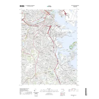
2023 Map of Boston South
USGS Topo · Published 2023About this map
Copps Hill Burial Ground and the Granary Burying Ground anchor the core of this modern survey, which details the dense urban and academic corridors of the Massachusetts capital. The map traces the winding course of the Charles River as it divides the campuses of Harvard University and the Massachusetts Institute of Technology from the historic neighborhoods of Back Bay and Roxbury. To the east, the sprawling facilities of Logan International Airport overlook the harbor islands and the strategic fortifications at Fort Independence. South of the city center, the terrain transitions into the residential districts of Dorchester Center and Jamaica Plain, where numerous cemeteries like Saint Marys Cem and the Dorchester South Burying Ground Cem provide significant points of interest for genealogists. The intricate network of waterways, from Fort Point Channel to the Neponset River, highlights the maritime and riverine character that has shaped the city's growth into the 21st century.
Find a feature on this map
146 named features on this map. Tap any name to fly to it.
Don’t see what you’re looking for? This feature index may not catch every label — zoom into the map to look around manually.
Map Details
Editions of this 2023 Boston South Map
This is the sole edition of this map. No revisions or reprints were ever made.
Other maps of this area

1885 · Abington
USGS Topo · 1:62,500

1886 · Dedham
USGS Topo · 1:62,500

1888 · Abington
USGS Topo · 1:62,500

1892 · Boston Bay
USGS Topo · 1:62,500

1893 · Abington
USGS Topo · 1:62,500

1893 · Boston
USGS Topo · 1:62,500

1894 · Dedham
USGS Topo · 1:62,500

1903 · Boston
USGS Topo · 1:62,500

1903 · Boston Bay
USGS Topo · 1:62,500

1919 · Dedham
USGS Topo · 1:62,500