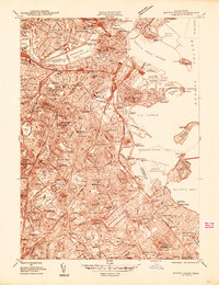
1944 Map of Boston South
USGS Topo · Published 1944About this map
The Charles River Basin and Boston Inner Harbor define this mid-century portrait of the city, revealing an urban landscape dense with academic, medical, and maritime history. Notable institutions like Harvard University and the Mass Institute of Technology anchor the northern reaches, while the green expanse of Franklin Park and the Arnold Arboretum offer structured relief to the sprawling street grids of Roxbury, Jamaica Plain, and Dorchester. The map illustrates the region's complex shoreline, featuring the growing Boston Airport and the strategic waterfront of the US Naval Reservation and Fort Independence.
Find a feature on this map
161 named features on this map. Tap any name to fly to it.
Don’t see what you’re looking for? This feature index may not catch every label — zoom into the map to look around manually.
Map Details
Editions of this 1944 Boston South Map
This is the sole edition of this map. No revisions or reprints were ever made.
Other maps of this area

1885 · Abington
USGS Topo · 1:62,500

1886 · Dedham
USGS Topo · 1:62,500

1888 · Abington
USGS Topo · 1:62,500

1892 · Boston Bay
USGS Topo · 1:62,500

1893 · Abington
USGS Topo · 1:62,500

1893 · Boston
USGS Topo · 1:62,500

1894 · Dedham
USGS Topo · 1:62,500

1903 · Boston
USGS Topo · 1:62,500

1903 · Boston Bay
USGS Topo · 1:62,500

1919 · Dedham
USGS Topo · 1:62,500