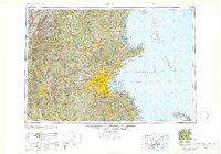
1948 Map of Boston
USGS Topo · Published 1948About this map
The coastal defensive landscape of the late 1940s is starkly visible in this regional study, which highlights a dense network of harbor fortifications protecting Boston. Batteries and military installations like Fort Independence, Fort Warren, and Fort Revere line the approach to the city through Massachusetts Bay and Broad Sound. This era reveals a Massachusetts interior defined by mature industrial hubs and integrated infrastructure, where the Merrimack River supports the manufacturing centers of Lowell and Haverhill while the Wachusett Reservoir serves as a critical hydrological anchor for the growing metropolitan region.
Find a feature on this map
61 named features on this map. Tap any name to fly to it.
Don’t see what you’re looking for? This feature index may not catch every label — zoom into the map to look around manually.
Map Details
Editions of this 1948 Boston Map
2 editions found

Other maps of this area

1885 · Abington
USGS Topo · 1:62,500

1885 · Duxbury
USGS Topo · 1:62,500

1885 · Worcester
USGS Topo · 1:62,500

1885 · Middleboro
USGS Topo · 1:62,500

1885 · Taunton
USGS Topo · 1:62,500

1886 · Gloucester
USGS Topo · 1:62,500

1886 · Lawrence
USGS Topo · 1:62,500

1886 · Worcester
USGS Topo · 1:62,500

1886 · Blackstone
USGS Topo · 1:62,500

1886 · Plymouth
USGS Topo · 1:62,500