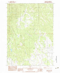
1983 Map of Boswell Mtn
USGS Topo · Published 1983About this map
War Eagle Mine and the Mountain King Mine mark the mineral-focused landscape of northern Jackson County in the early 1980s. This survey documents a transition in land use, where former settlements such as Spikenard and Beagle are noted only as historical locations, yet the complex network of creeks like Evans Creek, Rock Creek, and Snider Creek continues to define the drainage patterns of the region. The high ground is dominated by prominent peaks including Boswell Mtn, Cinnabar Mountain, and Chimney Rock Butte, which overlook the southern reaches of Sams Valley. To the west, Ramsey Lake and the winding Mineral Creek suggest the diverse terrain that supported both early mining ventures and the subsequent shift toward rural ranching and forestry. The inclusion of the Cinnabar Mtn Mine highlights the specific geology that once drew industrial interest to these ridges.
Find a feature on this map
29 named features on this map. Tap any name to fly to it.
Don’t see what you’re looking for? This feature index may not catch every label — zoom into the map to look around manually.
Map Details
Editions of this 1983 Boswell Mtn Map
This is the sole edition of this map. No revisions or reprints were ever made.
Other maps of this area

1891 · Ashland
USGS Topo · 1:250,000

1893 · Ashland
USGS Topo · 1:250,000

1897 · Ashland
USGS Topo · 1:250,000

1904 · Riddle
USGS Topo · 1:125,000

1908 · Grants Pass
USGS Topo · 1:125,000

1938 · Medford
USGS Topo · 1:125,000

1943 · Trail
USGS Topo · 1:62,500

1954 · Medford
USGS Topo · 1:62,500

1954 · Gold Hill
USGS Topo · 1:62,500

1954 · Wimer
USGS Topo · 1:62,500