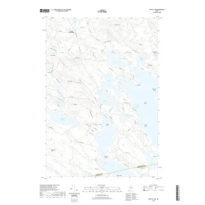
2018 Map of Bottle Lake
USGS Topo · Published 2018About this map
South Springfield anchors the northwestern corner of this landscape, where the settlement meets a sprawling network of glacial lakes and northern Maine ridges. The interior is defined by a massive interconnected waterway system, including the expansive Bottle Lake, Keg Lake, and Duck Lake, which dominate the central terrain. These waters are punctuated by distinctive landmarks like Dollar Island and Big Islands, while the surrounding elevations of Almanac Mtn and Lombard Mtn provide significant relief. The map reveals a complex web of timber and access roads such as Duck Lake Rd and Getchell Mountain Rd, tracing the paths of local industry through the dense woods. Further south, the remote reaches of Upper Sysladobsis Lake and the marshy edges of Cranberry Cove highlight the wilder character of the Penobscot and Washington County borderlands.
Find a feature on this map
101 named features on this map. Tap any name to fly to it.
Don’t see what you’re looking for? This feature index may not catch every label — zoom into the map to look around manually.
Map Details
Editions of this 2018 Bottle Lake Map
This is the sole edition of this map. No revisions or reprints were ever made.
Other maps of this area

1931 · Springfield
USGS Topo · 1:48,000

1932 · Nicatous Lake
USGS Topo · 1:48,000

1934 · Nicatous Lake
USGS Topo · 1:62,500

1934 · Springfield
USGS Topo · 1:62,500

1941 · Scraggly Lake
USGS Topo · 1:62,500

1941 · Wabassus Lake
USGS Topo · 1:62,500

1943 · Wabassus Lake
USGS Topo · 1:62,500

1944 · Scraggly Lake
USGS Topo · 1:62,500

1953 · Wabassus Lake
USGS Topo · 1:62,500

1954 · Millinocket
USGS Topo · 1:250,000